


![Text size [Small]](/media/system/images/font_small.jpg)
![Text size [Medium]](/media/system/images/font_normal.jpg)
![Text size [Large]](/media/system/images/font_big.jpg)
Shoushan
Time established: December 2011
Total area: 1122.654 ha
Administrative region:
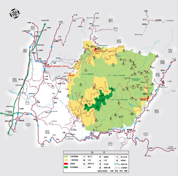
The park spans across the Gushan District, Zuoying District, Qijin District and Nanzi District of Kaohsiung City, with the largest range with in the Gushan District.
Landscape and Geology
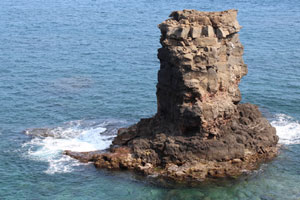
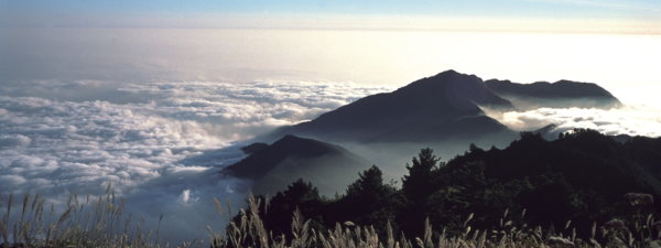
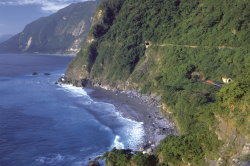
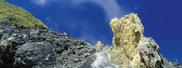
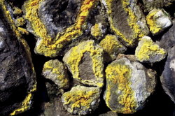
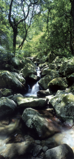
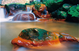
Shoushan was formed by sedimentation about 1.8 million years ago as part of the Kutingkeng Formation: badland terrain formed by dark grey mudstones interspersed with fine to medium grain sandstones, easily liquefy when in contact with water. About 1.25 million years ago, the area of the present day Shoushan was once a shallow water region, abundant with coral, algae, foraminifers and seashell growths. The remains of these organisms formed the hard limestone known as the “Kaohsiung Limestone” today, which was layered on top of the Kutingkeng formation and formed the basis of Shoushan Mountain. Erosion from latter periods resulted in large sedimentations that hindered the growths of corals, and terminated the formation of coral reefs. The Chijou layer was then formed with sand stones and mud stones. The rock layer was squeezed, uplifted, folded, fractured and jointed. The Kaohsiung limestone collapsed and accumulated on the southeastern side of Shoushan, forming Shoushan limestone. After weathering, erosion and rainwater erosion, the softer and weaker rocks beside the limestone were washed away and exposed the limestone, resulting in the frequently seen reef rocks, caves, gorges and cliff terrains on the mountain. Prolonged corrosion of the terrain resulted in the many limestone caves on the mountain, which are abundant with magnificent displays of stalactites, stalagmites and stone pillars, formed by precipitations of calcium carbonate.
Banpingshan is a single-sided, slanted mountain. There are cliffs on the west side of the ridgeline, covered mostly in collapsed limestone, while few areas are exposed mudstone (Kutingkeng) layers. The east side of the ridgeline has limestone layers, with growing thickness from north to south. A major characteristic of the development of coral reefs on Banpingshan is the large mixture of muddy detritus in the coral reef layer, forming interlacing layers of shallow water limestone and large amount of silicate detritus mud layers, which are significantly different from the common coral reefs formed on hard substrates (like the limestone in Hengchun).
Gueishan is situated within the Old City of the Zuoying District and faces Banpingshan. Originally, a coral reef limestone under the ocean, the mountain was raised as the result of tectonic uplift. Its geological structure is similar to both Shoushan and Banpingshan. Qihou Mountain belongs to the Kaohsiung limestone stratum that was formed from ancient coral reefs, with sand layers and clay layers interspersing the rock layers. Fossilized corals can be found frequently on the limestone and are evidence of an uplifted ocean floor.
Flora and Fauna
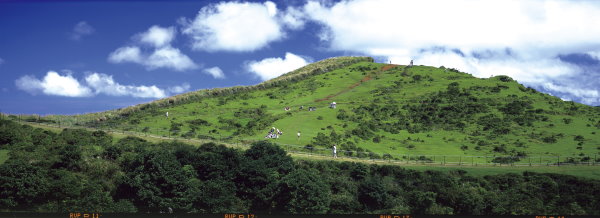
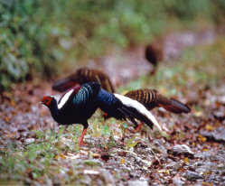
The vegetation in Shoushan can be classified into two types: original and human intervention vegetation. The original vegetation is mainly distributed on the hills and include species such as dominant societies of grassland, Vitex quinata and Kleinhovia hospita; dominant societies of common Papermulberry, Macaranga, and Molucca Mallotus; dominant societies of Taiwan Acacia and Subcostate Crape Myrtle; Ficus dominant societies; Naves Ehretia dominant societies; and dominant societies of Poisonous Wood Nettle and Chinese Taro. There are also introduced or invasive species like the dominant societies of Kassod Tree and Flamboyant tree.
Species that grow on human intervention lands, such as the mining areas and the cultivated lands and buildings near the foot of the mountain, includes the following Taiwan Acacia, Beef Wood, White Popinac, Flamboyant tree, Ficus tree, Linden Hibiscus, Indian Almond, Mahogany, Para grass and Bahia grass. Species on roadsides of the industrial roads include Roxburg Sumac, Macaranga, Common Papermulberry, Taiwan Acacia, and Silver-grass. Rattan species include Purple Flower Bean, Morning Glory, Humble Plant, and Weed Passion Flower.
The vegetation in the Banpingshan area can be classified into 3 types. 1) Restored vegetation in the cement plants, which mainly distribute on the eastern half and on the ridgeline. The species on the ridgeline are mainly Taiwan Acacia and White Popinac; the eastern half are mostly original species like Flame Gold-rain tree, Linden Hibiscus, Taiwan Acacia, Poonga-oil Tree, and Indian Almond. 2) Grasslands embedded mostly on steep rocky cliffs and on the ridgeline. Dominant species include Silver grass, Smallflower Beggarticks, and White Cogongrass. 3) Natural secondary forest mainly distributed on the western and northeastern sections of the mountain. Dominant species are Common Papermulberry, Macaranga, and some original Large-leaved Banyan and Ficus trees.
The vegetation in the Gueishan area is fewer due to its smaller surface area, having species such as Longan, Common Papermulberry, Macaranga, Naves Ehretia and Kamala Tree.
The common vegetation in the Qihoushan areaincludes the Swinhoe Fig, Macaranga, Filiform Cassytha, White Popinac, Sisal Agave, Naves, Ehretia, Coral Vine, Common Papermulberry, Linden Hibiscus, Milk bush, Common Lantana Yellow sage, Beef-wood, and Beach Morning Glory. The dominant tree species of the shrub layer includes Naves Ehretia, White Popinac, Swinhoe Fig, Common Papermulberry, Ficus tree, Macaranga, Coral Vine, Linden Hibiscus and Creepy Mallotus. The dominant tree species of the ground layer vegetation include White Popinac, Strengthvine Malaisia, Passiflora suberosa Linn, Grandular Petioluled Passiflora Common Achranthes, Pilose Beggarticks, Japanese Snail seed, Alligator Weed, Chinese fever vine and Common Jasmine Orange.
Historical and Cultural Sites
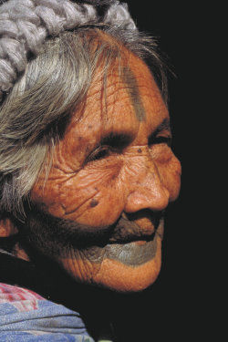
Kaohsiung was originally named “Dagao,” or “Takao,” the ancient site of the Dagao Community of the Makatto Tribe, a branch of the Siraya aboriginal tribe. The Makatto tribe planted bamboo forests around their homes to stop invasion from pirates, and in the Makatto language “Takau” means bamboo. The Han Chinese then phonetically translated the Makatto’s living place as “Dagao.” In 1563 the tribe was pilfered by the pirate Dao Chien Lin, and some of them migrated to the Ah Ho Lin (hills in Dashu) forming the Ah Ho communities in the areas of present day Pingtung City. By the time the Dutch arrived at Dagao, the Makatto tribe was no longer there. It is possible the Small Creek shellfish tomb site in Tsaishan is possibly a remnant of the Makatto tribe.
There are two main sites as mentioned above; one is the Taozhiyuan Site, located in the seaside Old Taozhiyuan village on the northwestern side of Northern Shoushan. This site contains the Taozhiyuan shellfish mound and urn coffin burial grounds, and is the earliest archeological site currently discovered in Kaohsiung City. The site is estimated to date back to 4,000 to 5,000 years B.C. The excavated finds included pottery and stone tools consistent with the Niu-chou-zi Culture period. The second site is Longchuan Temple Site, located in Northern Shoushan. This site includes the orchard in the southwestern side of Longchuan Temple, and another at the nameless creek behind the temple. An excavation in 1994 unearthed many remains of the Pepo tribe artifacts, such as shellfish mounds, pottery, stone tools and animal skeletons, dated approximately 400 to 2000 years ago.
During the Dutch Occupation periods, Dagao was already known as an excellent fishing ground. After the Koxinga ousted the Dutch during the Ming Dynasty, he set up colonies and cultivated in areas of present day Cianjhen, Houjin, Zuoying and Youchang districts. The Longshuei village in the Gushan District contains the Longchuan Well (Dragon’s Spring or Dragon’s Throat), which was rumored that Koxinga had once made camp here after he ousted the Dutch.
The Old City of Zupying was once called Hsinglungchuang, and was rumored to be one of the four encampments set up by Koxinga’s military in Kaohsiung during the Ming Dynasty. After the annex of Taiwan by the Qing Dynasty in 1684, Kaohsiung was under the administration of the Fongshan County, and Zuoying was chosen as the headquarters of the Fongshan County office, one of the important cities during Early Qing Dynasty. At the time, the walls had not been built, only the County Government Office was established. In 1722, the governor of Zuoying County, Liou Kwang-shi, built the first city wall made of mud. This was the first official record of the city building in Fongshan. In 1788, after the Lin Shuang-wen incident was pacified, the County Office was relocated to the present day Fongshan City, and the original fortress walls was called the “Old City.” The currently surviving remnants of the Zuoying City walls included the East Gate, South Gate, North Gate, West Goat, moat, Gongchen Well, and the Jinfu Temple outside the North gate. The current Old City was built in 1825 with contributions from government and private sectors, and was the first fortress in Taiwan to be built with mud and stone.
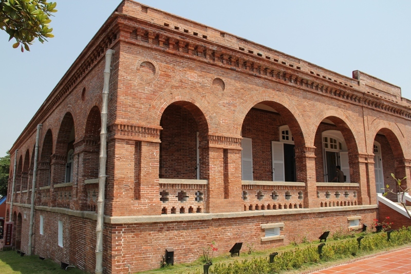
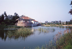
The 1858 Treaty of Tien-tsin and the 1860 Treaty of Peking forced the Qing Dynasty to open up the ports of Taiwan to foreign trade. To expand the economical benefits of trade with Taiwan, the British Government established a consulate at Takao, which was tasked with providing security for foreigners, business trade, exercising the rights of consulate decision, and negotiation with the locals. The British Consulate Residence of Takao is situated on the western part of Shoushan, on the peak of the Shaochuantou near the entrance of Sizhiwan Bay. This building bears witness to the history of the growth of ocean trade since the opening of the Takao Port, and also is the first consulate building funded and built by the British Office of Works. The consulate is an independent building of red brick and wooden corridors, the office section (including prisons and police quarters) is located near the beaches of Shaochuantou. The two buildings are connected via an old hiking trail.
After the Mudan Incident in 1874, the Qing court dispatched Shen Pao-chen, Naval Commissioner of the Qing Dynasty to Taiwan to improve the coastal defense. Shen invited British engineers to build a battery on top of Qihou Mountain in 1875. The Qihou Fortification, Dapingding Battery on Dagao Mountain and the Syongjhen North Gate Battery of the Shaochuantou formed a defensive line that oversees the security of the entire Port of Takao. The main entrance is modeled after the Chinese character “Eight”, the walls included brick designs of the Chinese character “double happiness囍” as well. In 1895 during the Yiwei War, the Japanese invasion force quickly occupied the deserted Chihou Fortification. The walls of the fort were left to ruin during the late years of Japanese colonial period, its cannons dismantled and melted.
The Qihou Lighthouse is located in the northern peak of the Qihou Shan in Qijin District. After the signing of the Convention of Peking in 1860, Takao officially opened its port in 1863, with merchant vessels coming and going frequently into Takao. The growing trading business demanded better navigational equipment. In 1883, the Qing Navy Lieutenant Wang Fu Lu commissioned British engineers to build a lighthouse in the style of Chinese square brick building on the northern peak of Qihoushan Mountain. The lighthouse is equipped with a British made class 6, single filament fixed light lantern with a visible range of about 10 nautical miles to ensure the nighttime safety of vessels entering the leaving the Takao Harbor. Now all that’s left of the original lighthouse is the foundation on the north side of the modern light house. During the Japanese colonial period, a new lighthouse was built by the Japanese in 1916 as part of the expansion of the Kaohsiung Harbor. The pedestal of the lighthouse was built in the post Renaissance Baroque style. The back of the main structure was an octagonal tower with a coned roof, containing a class 3 lantern with a visible range of 20.5 nautical miles. The lighthouse also has a 24-hour telegraph system and emits lights non-stop to guide the vessels at sea, ensuring maritime safety. The lighthouse is now maintained by the Directorate General of Customs, Ministry of Finance.
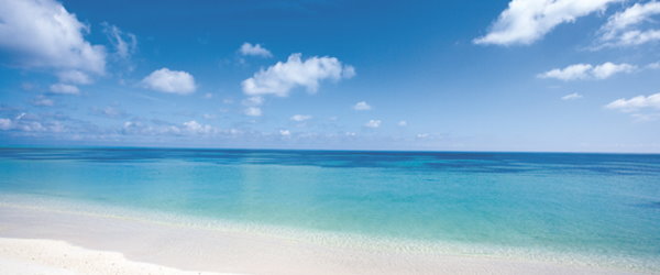
South Penhu
Time established: June 2014
Total area: 35,843.62 ha
Administrative region:
The South Penghu Marine National Park, the ninth national park and the second marine national park of Taiwan is born in 2014 after ratified by the Executive Yuan and announced by Ministry of the Interior. It is located between Wangan and Chimei of Penghu and consists of four main islands Dongjiyu, Xijiyu, Donyupingyu,Xiyupingyu, many islets, rocks and surrounding waters.
Landscape and Geology
China coastal current, a branch of Kuroshio current and south China sea current meet in his area. In winter, the China coastal current flow toward south. In summer, the south China sea current and a branch of Kuroshio current mix together and flow toward north. They bring abundant nutrient which nourish bountiful marine life. Species distributed in waters both north and south of Taiwan can be commonly found in this area. There are 254 fish species recorded here and at least 28 of them are newly recorded species in Penghu.
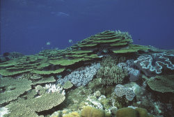
The ecosystem is unique and has a high species diversity compare to the other area of Penghu archipelago. Besides, one of the most health coral reef ecosystems of Taiwan can be found here because of its clear water and rich sunlight.
Flora and Fauna
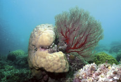
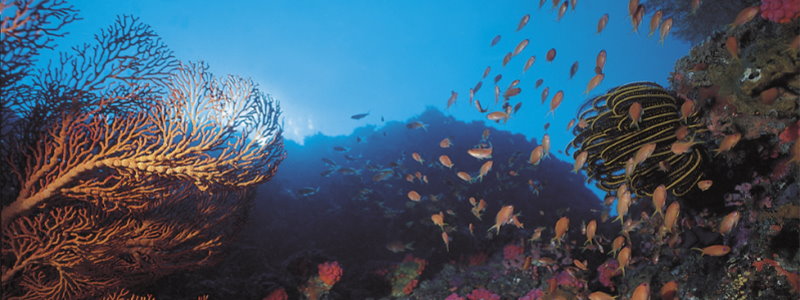
The Dongsha atoll is formed with typical tropical marine corals, with branching and table corals (Acroporidae) as the main reef-building organisms. They are distributed mainly on the surface and sides of the reef ridge. Currently, over 250 species of corals have been recorded, including 14 newly recorded species, such as the blue fire coral and a number of octocorals. The complex structure of this vast coral reef offers a perfect habitat for marine organisms to proliferate, including 556 fishes and many unrecorded species in Taiwan waters. Other than a wide range of fish and reef communities, there are colorful invertebrates living within, including 175 recorded mollusks, 28 recorded echinoderms and 33 recorded crustaceans.
Historical and Cultural Sites
There are western style houses, traditional Penghu houses and Caizhai which compose unique cultural landscape on the islands. The design of western style houses was a mixing of western and Japanese style. Traditional Penghu houses and Caizhai were built by piling up white rocks (coral reef rocks) and black rocks (basalt rocks).
All of these architectures are important cultural heritage of Penghu which presents the adaptation of the island people to the environment.
Come to visit South Penhu
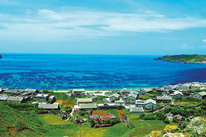
Dongyupingyu, Siyupingyu, Dongjiyu and Sijiyu located in southern Penghu are collectively called the four islands of southern Penghu; they are located from 119°30'E to 119°41'E, and from 23°14'N to 23°16'N. In addition to four larger main islands, the surrounding subsidiary islet reefs include Touchin, Tiehchen, Chungtsai, Chumuchiao and Chutouyu.
Due to the isolated environment of the four islands of southern Penghu plus the transition of industrial structures, inconvenient traffic and poor materials supply in recent decades, the population gradually relocates outside of Penghu. Therefore, except for a few residents that remain on the island, only a few visitors appear during week days.
The four islands of southern Penghu have not been over-developed, thus all the resources such as natural ecology, geological landscapes or historical monuments remain original, low-polluted and natural appearances. Moreover, those coral reefs with extremely high coverage rate in surrounding waters are precious assets of the ocean, hence the diverse ecological environment in the four islands of southern Penghu is worthy for tourism.
Taijiang
Time established: October 2009
Total area: 40,731.31 ha
Administrative region:
Land area includes public lands from Yanshui River to the Zengwen River of Tainan City, Tainan Black-faced spoonbill Reserve and Cigu Lagoon, covering 4095 hectares. The main focuses of the plan are to protect wetlands biodiversity, history of settlement and the characteristic salt and fishing industries. The sea area portion of the park encompasses the coastal water of 20-meter isobaths and the sea region of 20-meter isobaths from Yanshui Estuary to the south end of Tungchi Island in Penghu archipelago, which is 54-kilometers long and 5 kilometers wide. It was the main water route for early Han Chinese settlers crossing from Tungchi Island to Luerhmen. The sea thus encompasses 34,405 hectares.
Taijiang National Park is located in the southwest of Taiwan. Overall the park’s planned area stretches from the southern sea wall of Qingshan Fishing Harbor to the south bank of Yanshui River and is mostly public coastal land. Main island Taiwan’s most westerly point, Guosheng Lighthouse, is within the boundaries of the park which measures 20.7 kilometers north to south and has a planned area of 39,310 hectares, of which land will account for 4905 hectares The sea area will cover a band extending 20 meters from the shore and 54 kilometers long from Yanshui River to Dongji Island, an area of 34,405 hectares.
Tidal land, sandbanks and wetlands Special terrain and geological landscape
Tidal land is one of the most distinctive features of the park’s coastal landscape. The land along the Tainan coast has a gentle gradient and the rivers that flow into the sea on the west coast carry a large amount of sand. For topographical and geological reasons the water flow slows sharply when the rivers enter the sea with the result that the sand they carry is deposited around the river mouths. Over time the effect of wind, tide and waves causes the river mouth to gradually silt up and rise outwards, forming natural tidal land or sand banks. In the park, a wide tidal flat has been formed close to the shore while a number of offshore sand bars have also been formed in the breaking wave area, creating a special coastal landscape. Taijiang National Park has four main wetland areas: Zengwen River mouth wetlands, Sicao wetlands which are of international importance, and Qigu Salt fields wetlands and Yanshui River, wetlands which are of national importance.
Rich marine wildlife resources
A 1998 survey by Wetlands Taiwan found that Zengwen River mouth and Luermen River mouth areas have a total of at least 205 species of shellfish, 240 species of fish and 49 crab species…illustrating the ecological importance of these places. The productivity of wetlands is also much higher than ordinary farmland and the plentiful food supply attracts numerous wild creatures, fish and shrimp, and shellfish which live and breed there. Sicao wetlands has ten species of Fiddler crab: Uca arcuata (de Haan, 1835), Uca lactea (DP Haan, 1835), Uca borealis (Crane, 1975), Uca formosensis (Rathbun, 1921), Uca triangularis (A. Milne Edwards, 1873), Uca tetragonon (Herbst, 1790), Uca dussumieri (h. Milne Edwards, 1852), Uca crassipes (Adams and White, 1848), Uca perplexa (H. Milnft edwards, 1852), and Uca coarctata (H. Milne edwards, 1852). Yanshui River mouth is the only place in Taiwan where ten species of fiddler crab can be found.
Diverse land ecological resources
Most of the park area was originally part of the Taijiang Inland Sea. Over 200 years, land formed by silting and led to the area being turned salt fields and fish ponds and the establishment of villages. It is on the migration route for Asian after birds and every autumn and winter tens of thousands of birds pass through or stay on the salt fields, ponds or new land at the river mouth for the winter. Surveys carried out over the years by Wild Bird Society of Tainan show that almost 200 species of bird have been seen in the park area, with protected species, including the black faced spoonbill, numbering 21. The birds’ habitat is mainly the Zengwen River and Qigu Rivermouths, Qigu salt fields, Jiangjun River mouth, Beimen salt fields, Jishui River mouthand Bazhang River mouth.
The park area was settled early and the natural habitat has been disturbed quite heavily by human activities, consequently most of the mammals found here are species that are commonly seen on land. So far 11 species of mammal have been recorded, including small non-forest mammals like Japanese House Bat(Pipistrellus javanicus), house shrew (Suncus murinus)、and Taiwan bandicoot rat (Bandicota indica).
Five species of amphibians have been found in the park area: Spectacled toad (Bufo melanosticu), Chinese bullfrog(Rana tigerina rugulosa), Rice field frog (Rana limnocharis limnocharis), Ornate narrow-mouthed toad (Microhyla ornata) and Guenther's frog (Rana guntheri). Five species of reptile have also been found: Common House gecko (Hemidactylus Dumeril & Bibron, Five-striped Blue-tailed Skink(Eumeces elegans Boulenger), Stejneger's grass lizard (Takydromus stejnegeri Van Denburgh), Striped-tailed Rat Snake(Elaphe taeniura friesi) and Chinese common cobra (Naja atra(Cantor) ). The Chinese bullfrog, Guenther's frog, Stejneger's grass lizard, Striped-tailed Rat Snake and cobra are all rare and protected wild animals. Because most of the park area is developed, has little forest cover and human activity is frequent, terrestrial invertebrates are common. 26 species of firefly and butterfly have been recorded. The firefly (Pyrocoelia analis Fabricius) used be numerous in the park area but now is rarely seen. The population can be restored and firefly watching activities held in the park.
Diverse flora
Many species of plan grow within the park. According to the Industrial Development Bureau’s “Tainan Technology Industrial Park Environmental Monitoring” report (2005) and surveys by Wild Bird Society of Tainan and Kaohsiung Wild Bird Society, 205 species of plant, in 151 genera and 55 families can be found in the Dasicao area alone, with relatively rare flora including four types of mangrove: Black mangrove mangrove(Avicennia marina (Forsk.) Vierh.), Kandelia (Kandelia candel(L.) Druce), Lumnitzera racemosa Willd, Rhizophora stylosa and plants that live in sand and saline soil, including Seahore vine morning glory (Ipomoea pes-caprae (L.) Sweet subsp. brasiliensis (L.) Oostst.), Eulophia graminea Lindl, Myoporum bontioides, Beach Naupaka Scaevola hainanensis Hance, Blinding Tree (Excoecaria kawakamiiHayata).
Historic and cultural resources
Many Han migrants from China crossed the “black ditch” (the Taiwan Straits) and then settled in the Taijiang area. It thus had central role in the settlement of Taiwan and the formation of Taiwan’s ocean culture. Taiwan’s history and its ocean culture are inseparable and, in particular, the culture formed from the experiences of the early settlers is closely connected to the ocean culture of the Taiwan Straits. The shipping route between Xiamen and Luermen played a key role in the development of early society in Taiwan. It was the main channel for exchange between China and Taiwan and the main route taken by Han people migrating from China to Taiwan. On the Xiamen-Luermen route Penghu was a halfway point and also a shelter when needed. Wave after wave of Han people migrated to China from the 17th century. Sailing across the black ditch is a common historical memory of the people of Taiwan and a symbol of the settlement of Taiwan.
Most of the migrants were from Fujian and Guangdong provinces opposite Taiwan and were mostly from Zhangzhou, Quanzhou or Hakka people. Most of the people from coastal Quanzhou in southern Fujian made a living by fishing, drying salt, aquaculture and selling foreign goods so, when they migrated to Taiwan, they chose to live on the coast continuing to depend on the sea.
6000-7000 years ago the area from Yushan along the Zengwen River valley to the Tainan area was the area of activity of the Zhou tribe. They interbred with the Siraya Pingpu tribe of Taiwowan village and formed the Taivoan group, also called Sishe Pingpu. Around 300-400 years ago the Siraya tribe was distributed around the Tainan plain and the Taivoan group (a Siraya sub-tribe) lived on the Tainan plain on the middle reaches of Zengwen River. Records from the Dutch era show that the Pingpu population of the southern plain was much larger than anywhere else, and the villages in Xiaolong, Madou, Xingang and Wanli and other areas were large.
On April 21, 1661 Koxinga led 25,00 men on several hundred ships from Keluo Bay, Kinmen, passing by Penghu, landing at Luermen and Heliao Harbor and surprising the Dutch defenders. Using superior force they quickly took the weakly defended Chikan Tower (in today’s Tainan City) and then began a siege of the heavily defended walled city (today’s Anping district of Tainan City). After nine months of war, helped by Han migrants who had been helped by his father to cross the Taiwan Straits in earlier years, Koxinga defeated the Dutch in 1662. The Dutch governor was forced to surrender and the Dutch withdrew from Taiwan. He then worshipped the mountains and rivers, issued the order to settle the land and established the Kingdom of Dongning. “Chengtian Prefecture, covering south of Taiwan and part of the east, was established and Tainan became “Eastern capital”. Many communities in Tainan City and county were formed 400 years ago.
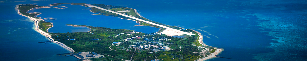
Dongsha
Time established: January 2007
Total area: 353,667 ha
Administrative region:
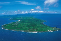
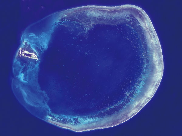
It is the southern gateway to the Taiwan Strait in the north of the South China Sea between Hong Kong, Taiwan and Luzon islands. The atoll is about 240 nautical miles from Kaohsiung in the northeast and 640 nautical miles from Taiping Island in Nansha in the south. The atoll is formed mainly by a coral reef. Dongsha Island is the only reef island above the sea surface among the Dongsha Atoll. Currently, it is under the jurisdiction of the Kaohsiung City Government.
Landscape and Geology
The Dongsha Marine National Park includes the Dongsha Island and Dongsha Atoll. Shaped like a horseshoe and covered with sand, the flat island has no apparent topological coverage but short tropical bushes flourish everywhere. Two sand ridges extend to the west of the island embracing a small lagoon, creating a shape that can be likened to that of a crab’s pincers. The lagoon is less than 1m deep at low tide. The Dongsha Atoll is a circular coral reef with a diameter of about 25km and a reef table of about 46km long and 2km wide, which emerges at low tide. According to estimates, it took millions of years for nature to form the Dongsha Atoll, making it one of the environmental wonders of the world.
Flora and Fauna
The Dongsha atoll is formed with typical tropical marine corals, with branching and table corals (Acroporidae) as the main reef-building organisms. They are distributed mainly on the surface and sides of the reef ridge. Currently, over 250 species of corals have been recorded, including 14 newly recorded species, such as the blue fire coral and a number of octocorals. The complex structure of this vast coral reef offers a perfect habitat for marine organisms to proliferate, including 556 fishes and many unrecorded species in Taiwan waters. Other than a wide range of fish and reef communities, there are colorful invertebrates living within, including 175 recorded mollusks, 28 recorded echinoderms and 33 recorded crustaceans.
Historical and Cultural Sites
Dongsha Island is the biggest of the South China Sea islands and was among one of the earliest to be developed. Records of fishermen fishing in the seas around Dongsha can be traced back to Jin Dynasty’s Guangzhou Ji over a thousand years ago: “The Shanhujhou (Coral Sandbar) is 500 li south of the county (Dongguan, Guangdong). People catch fish and harvest coral from the seas there”. Here “Shanhujhou” refers to Dongsha Island and its surrounding reef. Though fishermen often traversed these waters over the past 1000 years, Dongsha Island remained uninhabited due to its small size and remote location. Since ancient times, many vessels have passed the area on the South China Sea Silk Road, and have run aground and sunk due to the sunken reefs and shoals. Thus, it is an ideal location for marine archeology in the future.
Beautiful Dongsha
Shaped like a crescent moon and formed by coral reefs millions of years old, the Dongsha Atoll is located in the north of South China Sea. Due to its geographical and ecological features, the atoll is full of marine biodiversity. Designated by the government, Dongsha Marine National Park occupies an area larger than the combined area of the other 6 national parks (equivalent with one-tenth the area of Taiwan), with a border that extends 12 nautical miles away from the atoll. The Park includes islands, coastal forests, lagoons, intertidal zones, coral reefs, algae beds, ocean ecosystems, and other individual yet interdependent ecosystems. The resource characteristics of the park are different from the cora
Recreation Information
Marine National Park Headquarters 24 Demin Road, Nanzih District, Kaohsiung City, Taiwan 811
Service hours: 8:30-17:00
Tel: 886-7-360-1898
Website: Dongsha Marine National Park
Related Information
The Dongsha Atoll is currently a protected area under the jurisdiction of the Coast Guard Administration. There are no long-term inhabitants on the island. Tourism is not yet opened to the public until the completion of the National Park Protection Policy. Therefore, the general public cannot visit the island without prior permission. It is only currently opened only to government or academic/research institutions for official ecological investigations. All daily necessities used on the island are supplied from Taiwan by ship. The power supply and communication systems on the island need further improvements. Drinking water is supplied by a micro desalination plant on the island. Please visit the Dongsha Marine National Park Headquarters website for more details.
Transportation Guide
- Air transportation
- (1) Military aircraft
- Military aircraft travels to and from the island on alternate Tuesdays to transport supplies and for official business. The capacity is 70 persons and the load is 8000kg.
- (2) Private aircraft
- UNI Air has small aircrafts traveling to and from the island on Thursdays for carrying military and CGA officers.
- Sea transportation
- Private vessels
- Private vessels may be hired for transporting supplies to the island, including daily necessities, diesel, machinery, vehicles and construction materials. The schedule is one ship every 20 days. Though the maximum load is 350 tons each trip, only 100 tons of cargo is carried currently.
Precautions
- Please do not litter in the park.
- Please do not shout at or disturb wildlife (either at sea or on land).
- Please take only pictures and memories home with you, and do not remove any wildlife.
- Please do not step on corals. Please do not feed or play with any marine organisms.
- Please do not remove any coral sand.
- Please do not remove or damage any archeological items on the island.
- To protect the island ecology, please do not bring in any foreign animal or plant life.
- Please do not enter, photograph, survey or draw any military facility on the island without prior permission.
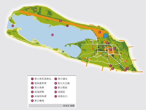
Dongsha Historic Site
In 1995, a team of professors from the Academia Sinica conducted an excavation of the “Dongsha Historic Site” located on the northern shore of the Dongsha Island lagoon. As the island lagoon is an environment subject to gradual silting, the site was probably suited to mooring boats of sampans while sailors used the shore as a place to rest, store goods, process their catch and stay out of the weather.
South China Sea Barrier Tablet
This tablet was erected facing the sea by the Ministry of the Interior in 1989 to introduce the strategic location, topology and climate of the island.
Dongsha Spiritual Fortressg
Located at the center of the square, the fortress was built during the Japanese occupation. It has a unique structure in which the national flag flies high up into the blue sky, visible to all on the island, and is a great boost for the morale of military officers.
Pearl of South China Sea
A pure white diamond-shaped landmark with rhombus patterns decorating the edges, this monument bears the symbol of Dongsha. Its pure form stands out among other tablets and monuments on the island.
Legend of Dongsha Dawang Temple
In the winter of 1948, the sacred statue of Guangong was brought to the island in a canoe. Military officers built a temple to worship the deity in 1975. Today, the canoe is preserved inside the temple. The Goddess of South China Sea—Machu is also worshipped here. In addition to offering incense and offerings, military officers returning home present gold medals to the god and goddess as a token of gratitude.
Navy Meteorological Station
Founded in 1925, the missions of the station include sonde observation and collecting meteorological data for the Central Weather Bureau for weather analysis and forecast. The station is quite important, for it is the only of its kind within an area of 100 nautical miles.
Kinmen
Time established: October 1995
Total area: 3,528 ha
Administrative region:
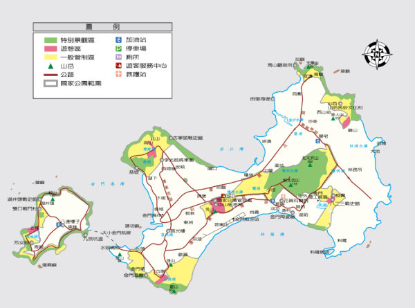
Jincheng Township, Jinhu Township, Jinsha Township, Jinning rural Township, Lieyu rural Township
Landscape and Geology
Both Kinmen and Lieyu islands, where the Kinmen National Park is located, are small subtropical islands with ancient wave-shaped hills, red-clay plateau and coastal lowlands. The granite hills are surrounded by lower plateau, and the peak of Taiwu Mountain, the highest hill on the island, is merely 253m above sea level. Most part of the island’s western half is a well-preserved red-clay plateau, but certain parts of it are badlands due to a partial cleft. Aggravated by seasonal precipitation, rivers on the islands lack base flow, and arroyos are found everywhere on the plateau. In some of the arroyos, traces of ancient human activities can still be found today.
Flora and Fauna
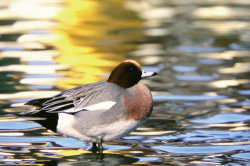
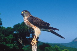
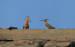
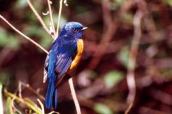
Birds are the most eye-catching creatures in the sky of Kinmen. There are over 280 species, including endemic species, such as the oriental magpie robin and the pied kingfisher. There are also rare species, such as the hoopoe, collared crow and the white-breasted kingfisher that can be found both in Kinmen and Taiwan. From autumn to the end of spring every year, large flocks of migratory birds nest and feed by the brook, forming a carefree and relaxing painting of nature.
Historical and Cultural Sites
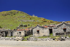
When the KMT retreated to Taiwan in 1949, the Communist Army assembled and landed on Guningtou on 25 October 1949 and engaged with the Nationalist Army. The Communists were defeated after a dreadful battle that lasted for 56 hours. The battle is called the Victory of Guningtou. On 23 August 1958, the Communist Army launched another strike and bombarded Kinmen for 44 days, which is later known as the August 23 Bombardment. In the following years, battles of various scales continued in the area, and the Communist Army fired nearly one million cannon rounds. As a result, Kinmen created island-wide defense works, leaving indelible marks on the island. The defense works include the underground combat tunnels in Cyonglin Settlement, the Jhaishan Tunnels built for logistics transportation, a large amount of anti-landing and anti-air poles, and the Beishan Building is covered with bullet holes. Today, time has changed. The historic sites of these battles and various military facilities have been included in the protected areas of the national park. Visitors can experience the history and sentiment of war in these relics.

Beautiful Kinmen
Kinmen was once called Wuzhou and has over 1600 years of warring and cultural history that nourished its beauty today. Traditional settlements that date back to centuries ago reveal the harmony between our ancestors and the nature. The layout of civilian housings represents the ethics of the patriarchal system. These settlements alsoefuse the southern Fujianese culture and the culture of immigrants across time in the same space.
The confrontation between the Communist Party and the KMT after 1949 turned Kinmen into a battlefield and put a mysterious veil over this island. When the war was over, the military control was lifted, and the mystery of Kinmen is unveiled; the island displays a multidimensional and touching facade.
After 1949, both the military authorities and civilian population began to plant trees and turn Kinmen from a barren island into a forest park on the ocean. Thanks to the coast control, the island’s tidal zone has a very rich ecosystem. Together with the ponds and reservoirs built for storing water, the island becomes a bird’s paradise. Magpies nest on the trees, oriental magpie robins chirps in the branches, hoopoes dig up the soil with their long bills in the open grassland seeking food.
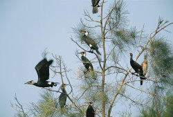
The summer fairy—blue-tailed bee-eaters come to Kinmen in packs to dig nesting holes for brooding. Great cormorants visit Kinmen for feeding and winter. At sunset, thousands of great cormorants return in split formation, weaving an amazing scene on the velvet blue sky. The richness of Kinmen awaits you to discover and explore.

Recreation Information
Kinmen National Park Headquarters 460 Boyu Road Section 2, Jinning Township, Kinmen County, Taiwan 892
Service hours: 8:30-17:00
Tel: 886-82-313-100
Fax: 886-82-313-134
Website: Kinmen National Park
Transportation Guide
- Far Eastern Air Transport: 46666789
- Uni Air: 886-82-324-481
- Trans Asia Airline: 886-2-4498-123
- Mandarin Airlines: 886-82-328-000
- Kinmen County Public Bus and Ship Administration: (082)332721
Precautions
- Visitors to Kinmen should make reservations early. In spring, fog is common and can delay flight schedule.
- In Kinmen, winters are cold, so visitors should bring warm clothing.
- For your safety, do not enter areas with landmine warnings.
- Traditional settlements are still resided. Please respect the residents’ privacy.
- Kinmen is a great place to enjoy bird watching. Please be careful not to disturb the wild birds or their habitat.
Cyonglin
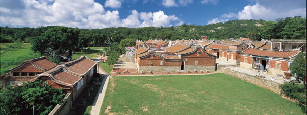
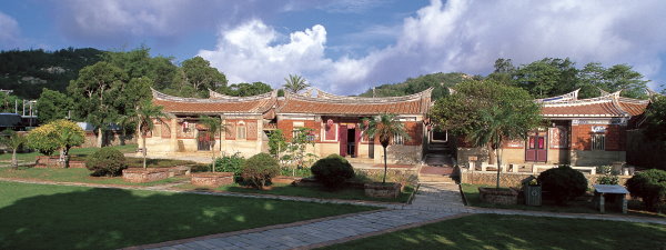
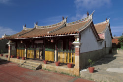
This is a naturally-formed settlement with a history of over 800 years featuring ancestral shrines of different family. As many candidates from Kinmen passed imperial examinations during the Ming and Qing dynasties, residences for government officials decorated with swallow-tailed design can be seen everywhere in the settlement. In the family temple there are various boards with inscriptions illustrating the merits of their ancestors. Inscriptions include “Winner of the Imperial examination”, “Head of scholars”, “Passed the Imperial examinations for five generations” etc. Besides the Tsai’ Family Shrine, the ancestral shrine of the clan in the settlement, every branch of the family has its own ancestral shrine. It is interesting that there are two branches sharing the same ancestral shrine. Given Kinmen’s strategic location, every citizen is a soldier at wartime, so it is also called the Combat Village.
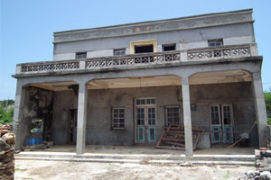
Shanhou
Shanhou is usually called Shanhou Folk Culture Village. It was built by Wang Guo-jen, an overseas Chinese leader in Japan, and his son Wang Jing-siang. The Village was donated to clansmen of the Wangs in Shanhou. All buildings were designed with swallow-tailed ridge, a traditional southern Fujianese style. The entire village including eighteen houses took 20 years to build, presenting a neat and delicate architectural style.
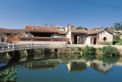
Shueitou
The saying, “There may be villages as rich as Shueitou, but there you will never find houses as beautiful as in Shueitou,” fully depicts the unique style of the buildings in Shueitou Settlement. The nine swallowtail ridge houses in traditional southern Fujianese style, the Huangs’ Family Shrine, the Huang’s Private School, Jinshuei Primary School and the Western-style buildings built in the early years of the ROC are the most representative and wonderful constructions in Shueitou Settlement, a village of multiple clans. The Gun Tower is also the most representative armament building in Kinmen.
Jhaishan Tunnels
The Jhaishan Tunnels built with uncanny workmanship is a splendid work and a historical witness of the defense works of Kinmen. Excavation of the tunnels began in 1961 in response to the military tension across the Taiwan Strait after the August 23 Bombardment. These tunnels, built during a period for 5 years, were for transporting logistics supply. They are divided into the tunnel and canal sections. The tunnel section is about 101m long, 6m wide and 3.5 high. The canal is about 375m long, 11.5m wide and 8m high for housing 42 boats.
WuWanZaiJu Inscription
Hiking in the Taiwu Mountain, you will see a stone inscription that reads Wuwanzaiju (Never Forget in Ju Town) written by Late President Chiang Kai-shek, erected at the 2/3 of the way. The Jhongsing Pavilion is located underneath the stone inscription next to the Taiwu Pavilion. When walking down the slope for about 5 minutes along the plum trees on both sides, you will spot the Haiyin Temple. The air is filled with the smoke of burning incense during the Chinese New Year because many worshippers visit the temple.
Cihu Lake and Shuangli Wetlands Nature Center
The Cihu Lake Bird-watching Area covers the Cihu Lake, Suanglihu Lake and Cihu Dike intertidal zone. There are fish farms, marshes, dry paddy fields, bushes and forests that form the complex wetlands ecosystem and the largest wild bird habitat in the park. The Shuangli Wetlands Nature Center displays the ecology and environment of Kinmen in full and supplies visitors with rich information.
Shei-pa
Time established: July 1992
Total area: 76,850 ha
Administrative region:
Located Wufong Township and Jianshih Township of Hsinchu County, Tai-an Township of Miaoli County, and Heping Township of Taichung County
Landscape and Geology
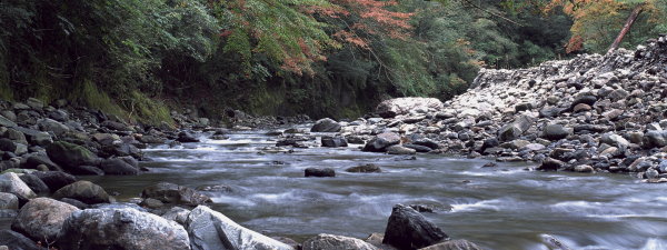
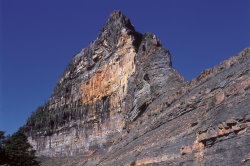
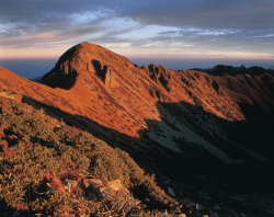
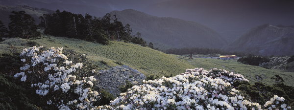
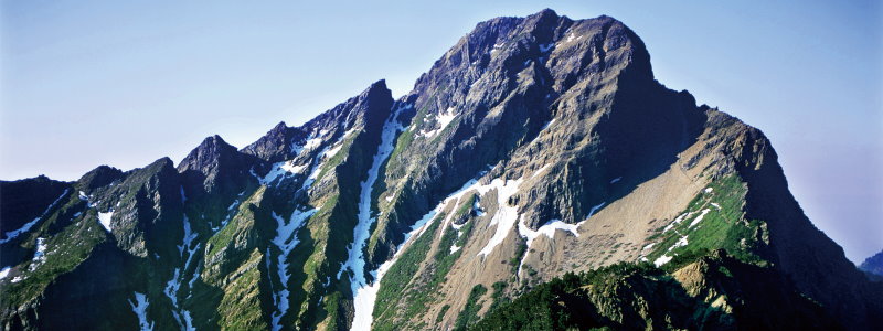
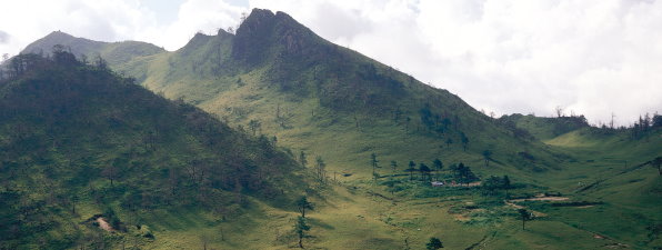
It is the third mountainous national park in Taiwan. Shei-Pa National Park is an area with high mountains, deep valleys and winding landform. There are 51 mountains above 3,000 meters high, of which 19 are listed as Taiwan Centuple Mountains. The landscape is versatile with magnificent scenic spots such as Syueshan Glacial Cirques, Daba Peaks, Busioulan Cliff and Pintian Mountain Fold.
Flora and Fauna
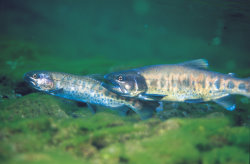
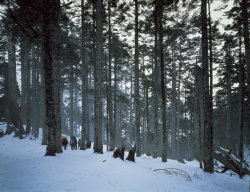
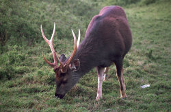
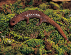
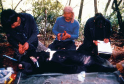
From Da-an River valley at 760 meters to Syue Mountain main peak at 3,886 meters, the range of elevation is about 3,000 meters. Complex terrains and diverse climates nourish a wide variety of flora. Among them, extensive Yushan Juniper forests and Taiwan White Fir forests are famous for their beauty. Moreover, animal species and population are also well preserved. Altogether there are 52 species of mammals, 150 species of birds, 16 species of fresh water fish, 26 species of reptiles, 14 species of amphibians and nearly 100 species of butterflies. The national treasure fish— Formosan Landlocked Salmon— is a relic from the Ice Age. Yet, destruction of their habitat has led to a significant decline in population. Only a small number of the fish can be found in Cijiawan Creek. The two banks of Cijiawan Creek are therefore designated as Formosan Landlocked Salmon Conversation Area.
Historical and Cultural Sites
The Shei-Pa area is home to Atayal and Saisiyat people. Being the legendary birthplace of the Atayal and Saisiyat ancestors, Dabajian Mountain is not only worshipped as a holy mountain, but is also an important pathway of Atayal people’s migration. Atayal people often live dispersedly at the foot of mountains below 2,000 meters where the weather is cool and land is suitable for farming. Saisiyat people live to the west of the Atayal, between 500 and 1,000 meters in altitude. The most distinct feature of the Atayal culture is the facial tattoo, and Saisiyat is famous for its very mysterious Pasta'ai (ritual of the pygmies). In addition, as early as around 3,500 years ago, cord marked pottery culture already appeared in the region, which is best represented by Cijiawan Creek Archaeological Site at the altitude of 1,698 meters, also known as the highest vestige dated back to the Neolithic Age found in Taiwan.
Beautiful Shei-Pa
Landforms in the park are mainly mountains and valleys. Syue Mountain, Dabajian Mountain and Wuling Quadruple Mountains are all above 3,000 meters high. Syue Mountain (3,886 meters) is the highest peak of Syue Mountain Range and also the second highest mountain in Taiwan. Shei-Pa National Park is named by combining one characters from this mountain and another from the “World Unique Peak”— Dabajian Mountain. Dajia River valley, Jiayang Alluvial Fan & river terrace, and meander core bring colors to park sceneries as well.
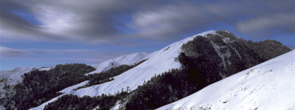
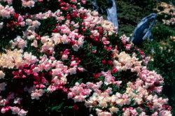
The Park has distinct four seasons due to the distribution of landform and humidity amid river valley. Early spring rain and plum rain make the park very misty, while in late spring, the mountain is full of wild flowers. In summer, typhoon and convective rain dominate. In autumn, temperature would fall drastically at night when cold air mass moves south and frost can be seen everywhere in the early morning to shape a colorful picture with a mountain full of red foliage and the azure sky. Snow is common in winter, delivering a rare snow view in Taiwan.
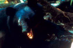
Complex and diversified landforms, hydrology, and climate have conserved abundant biological resources. There are altogether 26 endemic species of animals living in Shei-Pa National Park, including the valuable and rarely seen Broad-tailed Swallowtail Butterfly, Formosan Landlocked Salmon, Guanwu Formosan Salamander, and Formosan Black Bear, as well as endemic birds like White-throated Laughing Thrush, Formosan Hill Partridge, Mikado Pheasant, Swinhoe's Pheasant, and Formosan Yuhina. There are more than 1,100 species of vascular plants, of which 61 are rare plants, such as Taiwan Sassafras, Devol’s Balsamine, Dumasia miaoliensis, and Botrychium lunaria.
Recreation Information
Shei-Pa National Park Headquarters 100, Shueiweiping, Fusing Village, Dahu Township, Miaoli County, Taiwan 36443
Service hours: 8:30-17:00
Tel: 886-37-996-100
Fax: 886-82-313-134
Website: Shei-Pa National Park
Transportation Guide
- Shei-Pa National Park Headquarters & Wenshui Visitor Center
- (1) Take National Highway No. 1—exit by Miaoli Interchange (132.8K, Exit No.28)—Drive on Provincial Highway No. 6 in the direction of Miaoli for around 500 meters—Turn left to Provincial Highway No.72 in the direction of Dahu—Turn right at the end stop Wenshuei to Provincial Highway No.3—Turn left after crossing the bridge to Miaoli Rural Highway No.62 toward the Headquarters
- (2) Take National Highway No. 1—exit by Miaoli Interchange—take Provincial Highway No. 6 in the direction of Gongguan—Arrive at the meeting point of Provincial Highway No.3 and Miaoli Rural Highway No.62—Turn left to Miaoli Rural Highway No.62 toward the Headquarters
- Wuling Recreation Area
- (1) Take Yilan Branch of the Central Cross-Island Highway (Provincial Highway No.7) from Yilan, through Nanshan and Sihyuanyakou, eventually arrive in Wuling.
- (2) From Taichung, through Caotun of Nantou County, Puli, Wushe, Hehuan Mountain, Dayuling, and Lishan, then take Yilan Branch of the Central Cross-Island Highway, eventually arrive in Wuling.
- Guanwu Recreation Area
Take National Highway No. 3—exit by Jhulin Interchange—move forward in the direction of Jhudong—then take to Hsinchu County Highway No. 122—pass through Wufong, Cingcyuan—arrive in Tuchang—take Dalu Forest Road —Guanwu - Syuejian Recreation Area
- (1) Take Provincial Highway No.3 southward or northward—Dahu—turn to Miaoli Rural Highway No.61—pass through Erbensong— Shimasiian Forest Road— Syuejian
- (2) Take Taichung Rural Highway No.47 from Jhuolan Township of Miaoli County—pass through Shihlin Dam—take Miaoli Rural Highway No.61—Erbensong—Syuejian
Precautions
- Check road conditions, weather, and accommodations before visiting the park.
- Observe restrictions and be cautious of the signs in the park and follow park staff’s instructions.
- There is management station, a visitor center and a Shei-Pa Police Squad in every recreation area to provide information and first-aid services.
- Climbers must obtain Mountain Entry Permit and Park Entry Permit.
- Cijiawan Creek is a conversation area. Do not enter without prior permission.
- Mountainous areas are important water resources reservations and wildlife habitats. Please protect the natural environment and prevent fire.
- Do not travel alone in mountainous areas.
- To preserve water resources and land, Please do not leave the trail or take shortcuts.
- To protect the environment, no trash shall be left behind.
Wuling Recreation Area
Located in an ever-misty valley called “Shangri-La”, the whole region is mountainous with an average annual temperature of 15℃, which is cool and agreeable. Wuling is very steep but beautiful; the valleys of Cijiawan Creek, Wuming Creek, and Wuling Creek form a canyon; in the north. The four famous magnificent mountains on the ridge of Syue Mountain form the Wuling Quadruple Mountains. Along Taoshan Waterfall Trail, there are various red leaf plants, such as Taiwan Red Maple, Formosan Sweet Gum and Green Maple and animals such as Large-billed Crow, Taiwan Firecrest, and White's Ground Thrush can also be observed.
Guanwu Recreation Area
Guanwu Recreation Area is situated at an average altitude of 2,000 meters with an average annual temperature of 15℃. This area faces the valley formed by Ban Mountain, Jhen Mountain, and Sanrong Mountain. When humidity at lower altitude rises to this region, as the temperature drops, water vapor turns into fog to mist the whole valley. That is the reason why it is called Guanwu (seeing fog) in Chinese. There are altogether six major trails in the region: Yulun Trail, Kuaishan Big Trees Trail, Guanwu Waterfall Trail, Jhenshan Trail, Leshan Forest Road and East Branch of Dalu Forest Road. In the view-watching platforms and trails behind Guanwu Visitor Center, visitors can have a grand view of the magnificent towering rock ridge of Shengling Ridge. April to June is the best time for bird watching. Commonly observable species include Formosan Yuhina, Yellow-throated Minivet, Green-backed Tit, and White-eared Sibia.Butterfly season starts in early spring. There are Graphium eurous asakurae; in spring and Papilio hoppo with Highland Red-belly Swallowtail Butterfly in summer.
Syuejian Recreation Area
It is a natural recreation area in the park and at the altitude of between 800 and 2,100 meters. Due to the landform and slope direction, visitors can have a full view of the ridges of the magnificent Shengling Ridge and Dasyue Mountain in the park. Together with the abundant hydrological resources and well-preserved forests, it provides wildlife with a conducive natural environment. The areas along Beikeng Creek Historic Trail were gathering places of the Atayal people. Therefore, Atayal cultural relics and historical remains belonging to the Japanese colonial period are abundant.

Taroko
Time established: November 1986
Total area: 92,000 ha
Administrative region:
Stretching over Sioulin rural township, Hualian County, Heping rural township, Taichung County and Renai rural township, Nantou County
Landscape and Geology
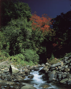
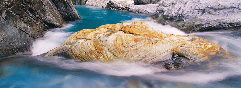
Taroko National Park is a mountain national park with almost 50% of the area located over 2000m above sea level and 27 of the Top 100 Mountains in Taiwan. The Hehuanshan Mountains, Heshecilai, Central Cianshan and Nanhu Mountain form the unique geographical landscapes in the park. The gorge is made up of layers of marble, schist, gneiss and phyllite, and the gorge itself is a miniature version of the eastern part of the Central Mountain Range. For the same reason, many special land formations are found there, including the ring valley, the gorge, the rift valley, high-level terrace and the meander core.
Flora and Fauna
The height difference between the mouth of Liwu River near sea level and the Nanhu Mountain in the area is 3742m. When climbing the gorge from the Central Cross-island Mountain, one can experience all four seasons in the same day. Plant landscapes change along with the altitude, and the plant ecology in the high mountain and limestone areas are the most characteristic. The rich land formations and plant faunae in the area provide the best habitats for various animals. Vascular bundle plants found there share about a third of all plant families across Taiwan. The terrestrial mammals there share about half of all mammal families in Taiwan. Ninety percent of the resident birds and over half of all butterflies found in Taiwan are seen in the park.
Historical and Cultural Sites
A group of people with a mixture of Kirin and Puyuma cultures entered the mouth area of Liwu River (Fushih site) about 2000 years ago and were the first inhabitants of Taroko. About 1200 years ago, a group of Provincial Shihsanhang people skilled in pottery entered and settled at mid- and down-stream from the Liwu River. About 200-300 years ago, Truku people and Tuse people from the Sedeq Group of the Truku Tribe moved eastward and settled in mid- and up-stream from the Liwu River and Tuse River areas. It was not until the Truko Incident of 1894 and the Wushe Incident of 1920, that these indigenous people were forced by the Japanese to migrate to the lower mountain area or flatland areas to facilitate their control and management. Today, a total of 79 historic sites of indigenous people are found in the area.
Beautiful Taroko
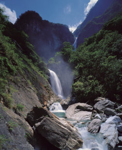
Taroko National Park is mainly located in the area surrounded by the Liwu River Valley, the eastern and western Cross-island Highways and the outer mountain areas. As the lifeline of Taroko National Park, the Liwu River starts from Hehuan Mountain and the north peak of Cilai Mountain and runs eastward across the mountains and valleys there for a distance of 58.4km before entering the Pacific Ocean in the north of Sinzheng. Over the past millions of years, the Liwu River has been cutting the oldest marble stratum in the geological history of Taiwan here in Taroko and the crust in the area continued to rise. Together with the combined effect of weathering and corrosion, traces of eras and tectonic plate movements over time are seen everywhere in the Taroko Gorge.
Taroko was described as “The most beautiful scene of heaven and earth and the greatest fun of all mountains and rivers.” Entering Taroko National Park is like walking into a splendid and spiritual ink wash painting, with great green mountains, murmuring rivers, thick forests, floating mists and clouds, valleys and mountains, and waterfalls and strange stones.
All have captivated the soul of countless travelers marveling at the greatness of nature.
Recreation Information
Taroko National Park Headquarters Fushih 291, Fushih Village, Siulin Township, Hualien County, Taiwan 97253
Service hours: 8:30-17:00
Tel: 886-3-8621-100-6 ext. 360 and 361s
Fax: 886-3-8621-263
Website: Taroko National Park Headquarters
Transportation Guide
- Visitors can drive to the park via the Suao-Hualien Highway (Provincial Highway No. 9), the Central Cross-island Highway (Provincial Highway No. 8), and Wushe Highway (Provincial Highway No.14A).
- Visitors may go to Hualien by plane or by train and take the local bus (Hualien Bus Company). Visitor may also rent a car or motorcycle to get there.
Precautions
- Please check the weather conditions and pay attention to the weather forecast before departure. Please also check the traffic conditions, your vehicle condition and relevant equipment. Please inform friends and relatives of your general itinerary.
- Please prepare warm clothes because great climate change is expectable when traveling along the Central Cross-island Highway that runs from low to high elevation.
- Beware of thick fog from Sinbaiyang to Guanyuan.
- It only takes a spark to start a fire. Beware of fire!
- The Central Cross-island Highway and trails running along it are subject to falling rocks and debris flows one week after downpours and earthquakes. Visitors should take extra precautions.
- Please prepare maps, compass and mountain entry permits and get a qualified guide when visiting the mountain areas on both sides of the Central Cross-island Highway.
- Small falling rocks often foreshadow large falling rocks. Please be alert to falling rocks and get away from any falling rock sites immediately. Please also warn others of falling rocks.
- Venomous snakes, poisonous bees are rampant in the area during summer and autumn. Beware of them.
- For your safety, always keep a distance from wildlife and please do not disturb or feed them.
- Please contact the Conservation Research Section of the headquarters at (03) 8621100 ext 701 before entering the ecology protected areas.
- Always pay attention to personal safety and the safety of companions. Please maintain environmental cleanliness and follow the National Park Act and relevant rules and regulations.
Suao-Hualien Coast
The section of Suao-Hualien Highway from Heren to Taroko is about 19km and located in the east of Taroko National Park. Along the highway, visitors can appreciate the soaring Cingsui Rift Valley, the splendid Pacific Ocean, and the wonderful scenes where mountains and sea crisscross one another. There are trails reaching the coast for sightseeing at the Heren Border Tablet (168.6KM) and Zhongde Tunnel North Entrance (176.4KM). It takes about 20 minutes’ walk.
Shakadon Trail
Originally called the Mystery Valley Trail, it is now an indigenous culture trail. The entrance is located down the stairs beneath the Shakadon Bridge. It is a path built within a marble cliff. It is about 4.5km to Sanjianwu. Water of the Shakadon River is clear all year round. The beauty of the water and stones are wonderful, and everywhere there is quiet and tranquility.
Yenzecou and Ciuchudong
The entire area is an uplifted coral reef platform filled with reefs and karsts. It is a superb spot for watching the sunset and the vistas of the park.
Lusui and Tiansiang
Lusui and Tiansiang seem to be perpetually in spring and have display centers, trails and accommodations. They are the important recreational locations in the gorge area. Plums and Sakura blossom at the chill in early spring. Yellow and red spots decorate the great green forest in late autumn to make the gorge even more romantic.
Green magic tree
The green magic tree in the foggy forest is a gigantic Lunta fir of about 3,200 years old. It is the only thousand-year-old tree on the Central Cross-island Highway. There are thick forests around with a wide range of species. In spring we can see the Rhododendron latoucheae Franch. & Finet, a breed of Rhododendron formosanum Hemsl., blooms all round. In autumn and winter, deciduous trees like the Acer palmatum Thunb. var. pubescens Li. and Acer rubescens/Acer morrisonense decorating the forests with their reddish leaves to embellish the entire area.
Hehuan Mountain
This is a famous spot for snow watching in winter due to its unique land formation However, flowers there blossom beautifully and luxuriantly. Visitors can enjoy ecological activities from the high-mountain trails on the Shihmen Mountain, East Hehuan Mountains and North Hehuan Mountains.

Yangmingshan
Time established: September 1985
Total area: 11,338 ha
Administrative region:
Located in the northern edge of the Taipei basin. The area includes some of the mountainous areas in Shilin and Beitou Districts of Taipei City, and some areas in the districts of New Taipei City such as Tamsui, Sanzhi, Shimen, Jinshan and Wanli.
Landscape and Geology
Different from the high mountain national parks, Yangmingshan National Park has a lower elevation. Even though mountain elevations range from only 200-1120 meters, beautiful landscapes such as ridges, valleys, lakes, waterfalls and basins are abundant. Andesite rocks make up most of the area's geology.
Flora and Fauna
Due to the effects of post-volcanic activity and precipitation, soil in the region is highly acidic. With the influence of the northeast monsoon and the area's microclimates, winter temperatures are much lower than the surrounding areas. The above factors cause the vegetation to differ from those in other regions at the same latitude. Some medium and high altitude plants can be found here such as Bird-lime Tree and Hairy Japanese Maple. Vegetation groups can be divided into subtropical monsoon rain forests, temperate evergreen broadleaf forests and mountain ridge grasslands. There are 1360 species of vascular bundle plants in the region. Some of the common ones are Red Nanmu, Large-leaved Machilus, Formosan Sweet Gum, Taiwan Cherry, Mori cleyera and Dark Spotted Cherry. The most famous is Taiwan Isoetes in Menghuan pond, an aquatic fern only found in Taiwan. Mt. Datun is one of the most well known places to see some of the 168 different species of butterflies in northern Taiwan. The best time to view the butterflies is from May to August. The most common ones are from the Families Papilionidae, Danainae and Nymphalidae. There are also 122 species of birds in the region.
Historical and Cultural Sites
Yangmingshan, previously known as Grass Mountain, was developed quite early because it is close to the Taipei basin. The past influence of the Ketagalan, Han, Dutch, Spanish and Japanese cultures, has left the area rich in historic heritage.
Beautiful Yangmingshan
Yangmingshan National Park is situated between the subtropical and temperate zones. The additional impact of the northeast monsoon leads to weather patterns that shape the unique scenic spots of Yangmingshan National Park.
In early spring, the green sprouts of azalea Rhododendron and Formosan Sweet Gum bring varied colors and great vitality to Yangmingshan. In summer, after misty rains, Cingtiangang grassland is full of the fragrance of green grass. When autumn comes, the red spiked silver grass sway in the wind along Mt. Datun, Mt. Cising and Cingtiangang make up a picture of the 「Datun Autumn Beauty」. At the end of the year,northeast monsoon brings cold wind and drizzle; the moving clouds and fog to make it a poetic landscape.
Picturesque Yangmingshan National Park is unique in its volcanic topography as well as in its close proximity to densely populated Taipei city.
Recreation Information
Yangmingshan National Park Headquarters 1-20, Jhuzihhu Rd.,Yangmingshan, Taipei City, Taiwan 11292
Service hours: 8:30-17:00
Tel: 886-2-2861-3601
Fax: 886-2-2861-1504
Website: Yangmingshan National Park Headquarters
Transportation Guide
- Taipei Main Station — Visitor Center:
Danshui MRT Line or Beitou MRT Line — Jiantan Terminal MRT Station — Bus Red No. 5 bus — Yangmingshan Bus Main Station — Park Shuttle Bus 108 - Taipei Fine Arts Museum — Visitor Center:
- (1) Bus 260 — Yangmingshan Bus Main Station — Park Shuttle Bus 108
- (2) Royal bus
- Jiantan MRT Station — Bus Red 5 — Yangmingshan Bus Station — Park Shuttle Bus 108
Precautions
- High temperature areas such as fumaroles and geothermal springs are unstable. Always stay on the trail.
- To avoid slipping, getting lost or snake and insect encounters, stay on the trail.
- Trails may be slippery, walk slowly.
- Use headlights at all times when driving on mountainous roads. In fog, use fog lights and drive slowly.
- Be prepared for rapid climate change before climbing mountains and hiking.
- In case of encountering poisonous snakes or wasps, leave quickly and quietly. Do not wear colorful clothes or use perfumes, so as to avoid attack by wasps.
Siaoyoukeng
Siaoyoukeng is located at the foot of Mt. Cising and above Datun Bridge on Yangjin Highway with an elevation of about 800 meters. It is a post-volcanic geological scenic spot, with views of an active fumarole, crystallized sulfur and the resulting landscape.
Mt. Cising
Mt. Cising is the its highest peak in Yangmingshan National Park and the Taipei City area. The mountain top was once a volcanic crater but in time has eroded into seven smaller summits with the main peak having an elevation of 1120 meters.
Yangmingshuwu
"Yangmingshuwu" (originally named Chungsin Guest House), is located on Chungsin Rd. close to Yangjin Highway. It covers an area of about 15 hectares and was built during 1969-1970. Today it is one of the important historic and cultural sites in the park.
Erzihping Three ponds are located in the lowlands between Mt. Datun and Mt. Erzih in the western area of Yamgmingshan National Park and are often covered in a mist.
Datun Nature Park
Datun Nature Park, is located between north Mt. Datun and Mt. Caigongkeng, and is next to county road 101 (Bailaka Road). This volcanic basin features regenerated temperate zone broadleaf forests.
Lengshuikeng
Lengshuikeng is located at the east side of Mt. Cising, and is now a dry lakebed dammed by lava from Mt. Cising and Mt. Cigu. The hot spring temperature here is less than 40℃, lower than the 90℃ in other areas in the Park, thus the name Lengshuikeng (cold water pit). It is the only mine bed of solid sulfur granules in Taiwan.
Jyuansih Waterfall
Jyuansih Waterfall is the upstream source of Neishuang Creek, with an elevation of about 14 meters. The waterfall falls as softly and elegantly as spun silk, and the rocks below take on a rusty color due to ferromagnesian oxidization.
Cingtiangang
Cingtiangang is a grassland terrace formed by northward flowing lava from Mt. Jhugao The location was a grazing area for cows in the early years It is now managed by the Taipei City Agricultural Association. The grassland is mainly covered with Carpet Grass and Crenate-leaved Eurya,which stretches for several miles and is a good place for holidays in northern Taiwan.
Tianxi Park Ecological Educational Center
Tianxi Park is situated in at the southeast area of Yangmingshan National Park. It is part of the subtropical broadleaf forest ecology influenced by the northeast monsoon. The various streams, luxurious forests, and close proximity to the Neishuang Creek in Taipei City provide many educational and tourism opportunities.

Yushan
Time established: April 1985
Total area: 103,121 ha
Administrative region:
Located in central Taiwan, covering Jhuorensi rural township in Hualian County, Taoyuan rural township in Kaohsiung County, Sinyi rural township, Nantou County and Alishan rural township, Jiayi County.
Geology and Topography
Yushan is located in the heart of Taiwan spanning Hualien, Kaohsiung, Nantou and Chiayi counties. Yushan National Park is a typical subtropical high-mountain park and one of a handful of areas in Taiwan where the primitive appearance is preserved. The park covers the tallest mountain in NE Asia, the Mt. Jade main peak with an elevation of 3,952m. Areas nearby the Yushan and Central Mountain Range are mountainous. There is a wide range of vegetation and faunae vary as the altitude changes. Due to the high elevation and vigorous topological cuts, tall mountains and deep valleys are the distinctive topological features of the area. There are 30 mountains over 3000m tall in the area ranking at the top 100 mountains in Taiwan and about 70% of the park area is over 2000m above sea level.
Fauna and Flora
Due to the changing topology and climate, plants grow luxuriantly in the area, thus nourishing diversified animal resources. Along the Raguragu River we even discover the Taiwan-unique Hemimyzon taitungensis and the Varicorhinus alticorpus (sharp-jaw barbell), the Formosan serow, Formosan sambar, Formosan black bear, the Formosan wild boar, the Formosan barking deer and the Formosan rock-monkey. They are quite active, large animals in the park. Due to the topological specialty of the park, gorges, rift valleys and wind gaps are found in the park with an altitude difference up to 3600m. Together with the changing climates, the park spans three climates: warm, temperate and cold climates. Therefore, there is a wide range of plants, including both subtropical vegetation and scenes on northern countries.
Culture and History
The human inhabitation on Yushan can be traced back to 1000 years ago. Located on high elevation and far away from the city, only the Bunun Tribe is still living in the mountain. The Batongguan Historic Trail marks an important milestone of the aggressive cultivation of Taiwan during the Qing Dynasty and is a testament to the hardships of the Han Tribe to cultivate the mountain. The Batongguan Traversing Trail and the Guanshanyeu Protection Line tells of the heroic defense of the Bunun Tribe against the Japanese invasion during the Japanese Colonization.
Beautiful Yushan
Yushan penetrates vertically along the south of the Central Mountain Range and runs horizontally across the northeast of Mabo Vertical Fault. It has been the heart of Taiwan ever since ancient times, acting as the ridge of Taiwan.
A third of the famous mountains and valleys on the island are located in the park area containing old geological structures. The spectacular topological landscapes, comprehensive animal, and plant ecologies surprise all who come in contact with them. Experiencing the ancient geological development through the discovery period of Western civilization, through to the massive movement of indigenous people to racial integration, Yushan has accumulated a rich and deep cultural heritage, including the Batongguan Ancient Trail that left behind from the Qing Dynasty and the culture and traditions of the Tsou and Bunun tribes.
The value of Yushan National Park, founds on its unearthed mountain and river landscapes and rich cultural and historical links, is incomparable and it is considered as the best amongst all national parks.
Recreation Information
Yushan National Park Headquarters 300 Jhongshan Road Section 1, Suili Township, Nantou County, Taiwan 55304
Service hours: 8:30-17:00
Tel: 886-49-2773-121
Fax: 886-49-2348-274
Website: Yushan National Park Headquarters
Transportation Guide
- Northwest Park Area
- (1) Suili — Yushan Section (Provincial Highway No.21): Suili of Nantou — Sinyi — Heshe — Tatajia Visitor Center
- (2) Chiayi—Yushan Section (Provincial Highway No.18): Chiayi — Alishan — Tatajia Visitor Center
- South Park Area
- (1) Tainan — Yakou (Provincial Highway No.20): Tainan — Jiasian — Baolai — Taoyuan — Meishan Visitor Center — Yakou
- (2) Taitung — Yakou (Provincial Highway No.20): Taitung — Guanshan — Lidao — Yakou
- East Park Area
Yuli — Yakou (Provincial Highway No.30): Yuli — Zolu — Nanan Visitor Center — Shanfeng Entry
Precautions
- Road condition in mountain areas is unstable and falling stones or landslides are common.
- Please do not linger or take pictures in places where there are falling stones or landslides.
- Afternoon showers or thick fog are common in summer, and skidding along the frozen road surface is common in winter. Please drive carefully and slowly!
- Formosan rock monkeys, Mikado pheasants and Swinhoe’s pheasants are commonly seen along the highways toward the park. Please drive carefully and do not feed them.
- From June to November is the mating season for hornets. When frightened they may easily sting during at this period. Please be careful.
- Please be well-equipped and prepare adequate food for hiking. Please also apply for mountain and park entry permits in advance when hiking.
- Do not litter in the park and please bring all garbage back down the mountain.
Yushan
The Yushan Mountain Range is located in the central of Taiwan Island. It has overlapping peaks, soaring mountains, steep river valleys with vegetations that varies as the altitude changes. There are three climates on the mountain, subtropical, temperate and cold. The faunae changes with the climate; there are also different kinds of wildlife. The main peak is 3952m above sea level, the tallest in Taiwan and NE Asia. The Taiwanese consider the mountain sacred.
Tatajia
The New Central Cross-island Highway in Tatajia is the gateway to the northwest of Yushan National Park and to mountain climbing. The highest point of the New Central Cross-island Highway is located at about 2600 above sea level at the intersection of Provincial Highway Nos. 18 and 21. Many trails have been planned there, such as the trails toward the Dongpu Prairie, Lulinshan and Cizishan. The spectacular and diversified ecological resources along the trails are suitable for hiking.
Batongguan
Batongguan is the water divide that one must take when visiting the Chenyaolan River and Laonon River. It is also the intersection of the Batongguan Historic Trail built during the Qing Dynasty and the Batongguan Traversing Trail built by the Japanese during the their colonization. There are rich cultural and historical relics, prairie landscapes and animal habitats. It is the favorite of visitors when flowers are blossoming in spring.
Tianzi
The Southern Cross-island Highway is the access to the major recreational spots in the south of Yushan National Park. The Meishan Recreational Area along the highway is filled with Bunun culture. The Tianzi Recreational Area is a high-mountain lake with quiet scenes. The Jhongziguan Trail is an ideal spot for leisure and hiking.
Walami
Walami in Nanan is a famous attraction in the east of Yushan National Park. It is the hometown of the Formosan black bears. The Walami Trail forms the east section of the Batongguan Cross-mountain Route built by the Japanese during the their colonization and is the ideal trail for ecology visitors.
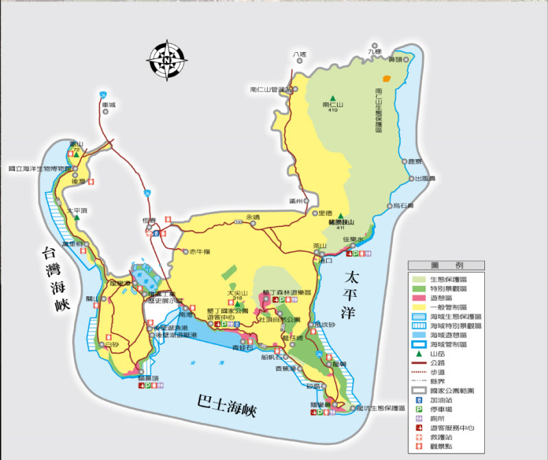
Kenting
Time established: in September 1982
Total area: 32,570.14 ha ( land area 17,678 ha; marine area 14,891 ha )
Administrative region:
Situated on the Hengchun peninsula, stretching over Chechen rural township, Hengchun township and Manjhou Rural Township, Pingdong County
Landscape and Geology
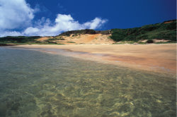
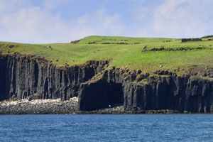
Kenting National Park has gorgeous terrains and landscapes. Shaped long and narrow, the park extends across the Hengchun Valley Plain from south to north, bisecting the park into an eastern and a western section. The extensive surface of Longluan Lake lies silently at the bottom of the valley. Two extended arms intrude to the ocean southward from the park. The one on the left is Maobitou cape and on the right is Eluanbi cape Along the 70km coastline there are rich landforms, including the strange and delicate coral reef, the pure and fine sandy beach, and the ever-changing sandstone coast. Walking toward the inland, there is a quiet and tranquil lake basin, a precipitous isolated peak and a sea cliff. All these display the rich and varying terrains in Kenting National Park.
Flora and Fauna
A wide range of flora is found within the park covering the mountain forest and coastal plain due to the terrains and tropical climate. Plants include a rare coastal forest, a primitive tropical monsoon forest and coral reef plants that fear neither wind nor wave. The flourishing and well-structured plant communities also provide ideal habitats for animals. The rich Flora and fauna make the park a treasure of biology.
Kenting National Park is the first national park in Taiwan particularly to include both marine and terrestrial areas. In the marine area of the park, the Black Current runs across and maintains the annual water temperature at 22-29℃. Also, as there is no emission from the river, and the water is clear and temperate; the park is ideal for its wide range of living organisms. The coral reef is a magnificent underwater palace where colorful coral fishes, shells and algae grow there to form a natural undersea wonder.
Historical and Cultural Sites
Besides the rich natural scenic resources, there are many valuable cultural assets in Kenting National Park. Currently, 70 prehistoric sites have been discovered, and the Kenting and Eluanbi prehistoric sites are the most representative.
Beautiful Kenting
Since 5000~6000 years ago, an ethnic group of mariners already cultivated the Austronesian civilization in this place surrounding by mountain and sea.
In the mid-18th century, this caudal fin in the south was once a part of the world stage.
The tropical climate here has nourished an exuberant flora. The downhill wind ushers in many migratory birds every winter and makes Kenting National Park a sacred place for bird watching.
Combining the pulse of the mountains and the breath of the sea, Kenting National Park has too many beautiful scenes to be fully appreciated all at once.
Kenting National Park has gorgeous mountain and river views, magnificent marine scenery and distinguished cultural assets. It is an ideal place for visitors who enjoy traveling and recreation, and is a perfect spot for professionals to experience natural landscapes.
Blue sky, sunshine, azure sea and white sand are the best illustrations of this tropical national park which affords citizens the opportunity to see a blue coral reef without traveling overseas.
Kenting National Park Headquarters
596 Kenting Road, Hengchun Township, Pingtung County, Taiwan 94644
Service hours: 8:30-17:00
Tel: 886-8-886-1321
Fax: 886-8-886-2047
Website: Kenting National Park Headquarters
Transportation Guide
Kaohsiung-Kenting
- Take buses of the Kaohsiung Bus, Pingtung Bus, Koukuan Bus and Bus Chunnang companies.
- Schedule: 40-50 minutes a bus between 00:00 and 04:00. 6-10 minutes a bus during peak hours and 15-20 minutes a bus during off-peak hours.
- Dial 886-7-235-7841 to the joint operation center or visit the King Bus website for details.
Precautions
- Please study the information relating to the characteristics, difficulty and length of trails and weather information before departure.
- Please do not enter the park after a typhoon or earthquake.
- Please follow the trail routes and stay away from the cliff during high winds.
- Beware of poisonous plants & animals
- Please do not collect shells, reefs and plants or disturb the wildlife.6. Please bring away all garbage.
Baisha Bay
This is a beautiful and quiet bay with a clean, white sandy beach about 400m long and a platform barrier in the east. It is quiet even in winter and is perfect for all kinds of beach and marine recreational activity.
Maobitou
As a cape in the west of southern Taiwan, Maobitou is a typical coral reef abrasive landform overlooking another cape, Eluanbi across the Bashi Channel. It is called the “tip of the cat’s nose” because the shape of the adjacent coral rock fallen from the cliff.
Guanshan
The entire area is an uplifted coral reef platform filled with reefs and karsts. It is a superb spot for watching the sunset and the vistas of the park.
Longluan Lake
This deep-water pool has an extensive surface. The water is ordinarily used for irrigation and attracts migratory birds in autumn and winter, and has therefore become a paradise for birds. The nature center on the west bank is the first bird ecology museum in Taiwan and provides exhibitions of bird ecology and dynamic bird observation activities.
South Bay
Previously known as the dabanle, it was a whale-hunting site during the Japanese colonization and is now a fishing village. Its clean and pure beach of about 600m long is ideal for all kinds of beach activities.
Kenting Forest Recreation Area
Previously known as the Kenting Park, it was developed as a tropical botanical garden during the Japanese colonization. There are uplifted coral reefs and thick forests in the area. Besides the native species, there are imported tropical plants. Wonderful scenes, such as the limestone cave, a rift valley, the buttressed root of the looking-glass tree and the pending banyan valley are all worth visiting.
Sheding Nature Park
The entire area is an uplifted coral reef covered with a coral reef rift valley, limestone cave and grassland. The wind shaped trees always facing the northeast monsoon are like natural bonsai looking trees.
Shadao
A shell sand beach about 220m long, the islet contains high levels of calcium carbonate, at 97%. Therefore, it is a protected area of the national park. On the islet there is a shell sand exhibit house for visitors to learn more and see more about shell sand.museum in Taiwan and provides exhibitions of bird ecology and dynamic bird observation activities.
Eluanbi Park
Eluanbi is a cape located in the furthest southern tip of Taiwan at the intersection of the Bashi Channel and Pacific Ocean. The park is covered with coral rocks, unique uplift coral plants and tropical marine plants. Besides the well-known lighthouse, there is a prehistoric site from about 5000 years ago.
Fongchueisha
The dry and wet seasons on Hengchuan Peninsula are clearly divided. The southwestern air current in summer brings in lots of rain to the region, and the rain washes away sand on the peninsula into the ocean. The powerful downhill wind in winter brings the sand back to the top of the cliff from the shore. This makes for a unique weathering landform in the area.